|
Geographic Description:
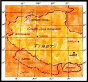 Tibet, also known as Xizang (in the Pinyin form), is one of the five autonomous regions of China and one of China's 22 administrative divisions. It is the largest region with the smallest population, amounting to only 2,285,000 in 1997. Existing almost in its own geological setting, as a vast plateau at an average height of some 15,000 feet, Tibet has remained at least for Westerners, one of the last great unexplored regions on the Earth. Nested in its rolling hills and steppes are immense lakes that give birth to many of Asia's mightiest rivers. For example, the Yarlung Zangbo cuts through the Himalayas to become the sacred Brahmaputra in India, and the Nu ("Black River") becomes the Salween as it flows through Myanmar (Burma) and the border of Thailand. The Mekong, the Yangtze, and the Hwang Ho rush down hundreds of miles of precipitous gorges to irrigate the rice fields of China and Indochina that feed more than a quarter of humankind. The Indus River of Kashmir and Pakistan also originates in the meltwaters on the Plateau of Tibet.
The geographical boundaries of Tibet have added to its isolation, with the Kunlun and Altun ranges to the north, the Himalayas to the south, the Pakirs or Karakoram Ranges to the west, and the high mountains of Szechwan to the east. Roads were bad, and the only means of travel in the interior were on foot or by horse or yak. Until recently, there was no wheeled transport, and the story is told of how the King of Nepal, on a visit to Tibet, had to have his car completely dismantled and carried piece by piece across the Himalayas by Sherpas.
In 1980, the People's Republic of China timidly reopened the borders of what now forms one of its largest provinces to a limited number of foreign tourists and mountaineers, most of whom have only been permitted to pay brief visits to Lhasa, the capital, and to Shigatse.
The whole Tibetan plateau and the Himalayas are constantly subjected to massive movements of the Earth's crust, which have gradually given them their shape and form. The entire plateau, with its vast mountain ranges, has been pushed up as a result of the collision of India (on the Indian plate with Australia at the southern end, all moving northwards) with Asia (on the vast Asian plate moving southeastwards). Earthquakes are today's evidence of this continuing process. Scattered throughout Tibet are occasional outcrops of hot springs where water boils just below the surface as it emerges through deep fissures and faults in the Earth's crust. Settlements often take advantage of these "hot" springs and in modern times several geothermal power plants have been built to convert this heat energy into electricity.
Tibet can be roughly divided into two areas; the "high" plateau of the Quidam Basin, with average elevations above 15,000 feet, and the core area of Tibetan culture comprising the "low" plateau between the Himalayas to the south and the Transhimalayas lying not far to the north. In this area, some valleys lie below 7,000 feet, climate is comparatively mild, and some cultivation is possible. Here lies Tibet's main population cluster, including the crossroads capital of Lhasa. The Chinese government has made investments to develop these valleys, which contain excellent sites for hydroelectric power projects (some have been put to use in a few light industries) and several promising mineral deposits. The Qaidam Basin region however in the north, lying several thousands of feet below the surrounding Kunlun and Altun Mountains, has always contained a concentration of nomadic pastoralists. Recently, however, exploration has revealed the presence of oil fields and coal reserves below the surface of the Qaaidam Basin, and the development of these resources is now under way.
Historical Overview:
Tibet came under Chinese domination during the Manchu (Qing) Dynasty in 1720, but the territory regained its separate status in the late 19th century. China's communist regime regained control following the invasion of 1950; in 1959, China crushed a Tibetan uprising after Tibetan villages tried to resist the Chinese presence. Tibetan society has been organized around the fortress-like monasteries of Buddhist monks who paid allegiance to their supreme leader, the Dalai Lama. The Chinese wanted to modernize this feudal system, but the Tibetans clung to their traditions. In 1959, they proved no match for the Chinese armed forces: The Dalai Lama was ousted, and the monasteries were emptied. The Chinese destroyed much of Tibet's cultural heritage, looting the region of its religious treasures and works of art. Their harsh rule took a severe toll on Tibetan society, but after Mao's death in 1976 the Chinese relaxed their tight control. Although amends were made (religious treasures were returned to Tibet, monastery reconstruction was permitted, and Buddhist religious life resumed), pro-independence rioting has been frequent since 1987, and the Chinese have again tightened their grip. Since its annexation in 1965, Tibet has been administered as an Autonomous Region.
Lhasa, the administrative and religious capital of Tibet, is actually divided into two distinct sections. The entire modern part surrounding the Potala palace has been built by the Chinese during the past 40 years. It is in these new block-shaped buildings with corrugated metal roofs that the majority of the Han (Chinese "proper") population lives. The Potala itself was mostly built by the "Great Fifth" Dalai Lama in the 17th Century and has been the residence of all successive Dalai Lamas up to the present 14th holder of the title.
The Yak:
The yak is a hefty, primitive looking beast, somewhat resembling the ancient paintings of bisons. The high plateau is the natural ecological niche for this unique animal, which flourished best at heights above 13,000 feet. Below this altitude, there is a similar, though less powerful animal, the dzo, which is actually a crossbreed between a yak and a cow. Strong enough to do heavy field tasks, yaks also supply their owners with milk, butter, meat, dung, and hair. Apparently the value of yak dung in the woodless regions of Central Asia cannot be overestimated. It is the main fuel of the country and burns with a hot, steady flame.
|